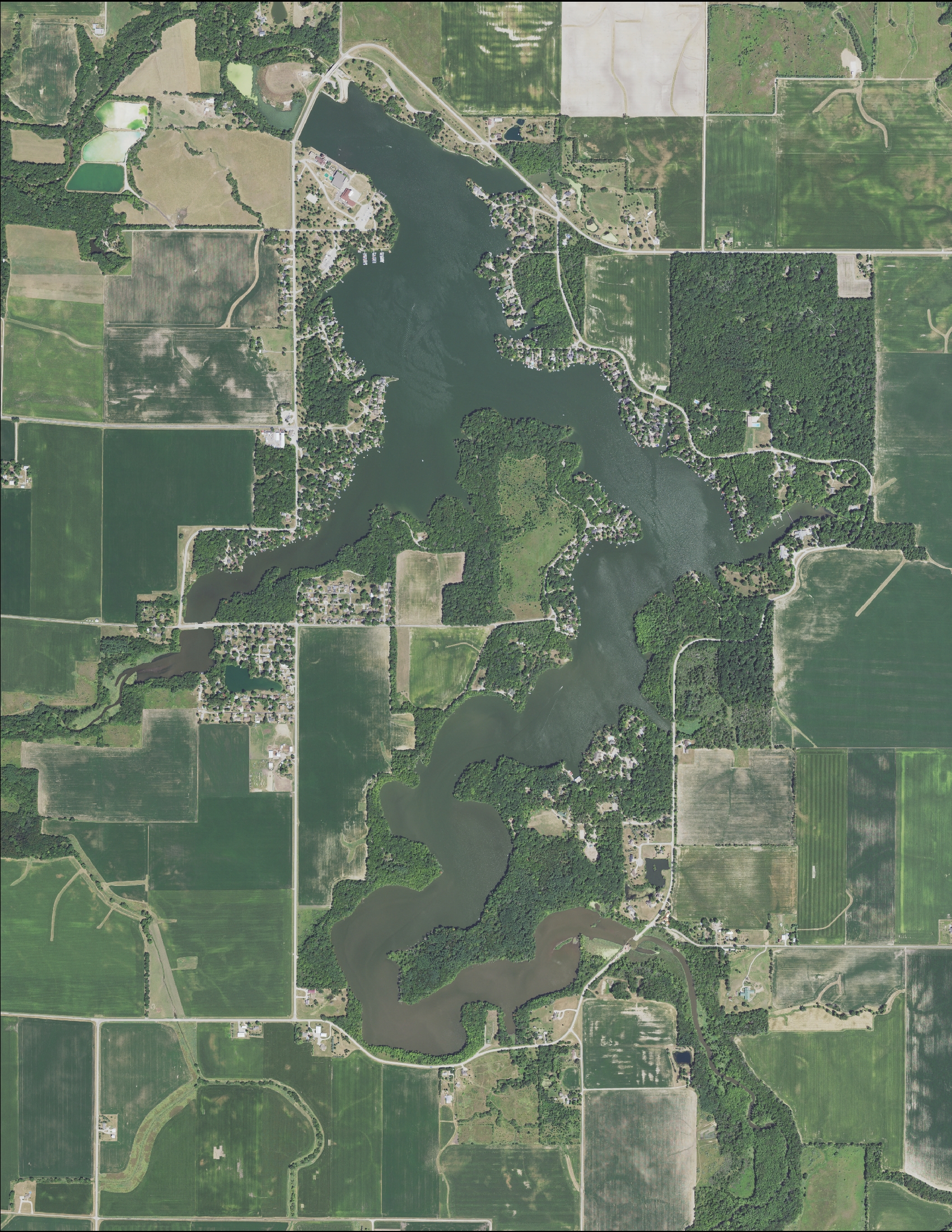
Lake Bloomington
Lake Bloomington serves as the primary drinking water supply reservoir for the City of Bloomington. Recreation and residential development are the second and third priority uses. The roughly 43,000 acre Lake Bloomington watershed is predominately row crop agriculture in corn/soybean rotation with extensive tile drainage. The watershed surrounds both Towanda and Merna. The City of Bloomington and the Town of Normal are expanding into the southwestern edge of the watershed. Money Creek delivers most of the water from the rest of the watershed to Lake Bloomington.
Lake Bloomington Watershed
Watershed ~ 43,100 acres/70 square miles
Lake ~ 570 acre surface area/9.5 miles of shoreline
LAKE BLOOMINGTON WATERSHED SOIL EROSION AND CROPLAND TILLAGE TRANSECT SURVEY
The Illinois Department of Agriculture, in cooperation with Illinois Soil and Water Conservation Districts, completes a Soil Erosion and Cropland Tillage Transect Survey. The survey aims to gather more information about the implementation of conservation farming practices, and to assess the condition of McLean County. Tillage data is gathered for corn and soybeans, and the county’s T levels are assessed. “T” represents the tolerable soil level loss, or the amount of soil that can be replaced naturally by the decomposition of crop residue. In addition to T levels and tillage data, the survey compiles some information on cover crop use.
Agricultural runoff is a significant source of phosphorous and nitrate-nitrogen loading into Illinois waterways. Nutrient runoff is carried by the rivers and streams to the Mississippi, and down to the Gulf of Mexico. Nutrient concentration in the Gulf of Mexico is so high that it causes algal blooms, and subsequent dead zones called “hypoxic zones”, devoid of life. To combat this issue and promote soil health and water quality, Illinois’ Nutrient Loss Reduction Strategy (NLRS) was created. The NLRS aims to direct efforts to reduce nutrients from point and non-point sources. The goal is for Illinois to reduce its phosphorous load by 25% and its nitrate-nitrogen load by 15% by 2025. The eventual target is a 45% reduction in the loss of these nutrients to the Mississippi River.
Some conservation practices that help reduce nutrient runoff include cover crops, filter strips and buffers, conservation tillage (no-till, strip-till, etc.) and habitat projects, such as pollinator habitat and constructed wetlands .
LAKE BLOOMINGTON WATERSHED GRANT & STUDY UNDERWAY
Focused watershed planning has been a high priority of the McLean County Soil and Water Conservation District, especially in the Lake Bloomington Watershed. New funding is available to farmers within the watershed thanks to this new collaboration and study being conducted. The focus centers around the adoption and implementation of cover crops, reduced tillage and 4R nitrogen management practices and their impact on water quality. The partnership began with an effort by the SWCD, City of Bloomington, Purdue University and the University of Illinois to propose a grant to the Illinois Soybean Association. Those efforts proved successful when the grant was awarded, and planning efforts are already underway. The goals of this collaboration will be to evaluate the long-term stream and lake water quality data set of Lake Bloomington watersheds in correlation with the change of conservation on the landscape. The results will generate a firm background of nutrient (N and P) and sediment loss over time. Modeling of a “Nutrient Loss Risk Analysis” will identify high and low risk nutrient loss zones (“priority areas”) of the watershed. Those results will help us engage farmers by encouraging cover crop and conservation adoption in the priority area watershed zones through farmer engagement. This effort also will provide strategic farmer education within the watershed through the implementation of On-farm learning network sites and farmer meetings. Farmer’s can expect more detailed information and outreach in the near future.
Partners and Grant Team: Illinois Soybean Association, Dr. Shalamar Armstrong, Associate Professor, Agronomy Department, Purdue University-Research Director Dr. Rabin Bhattarai, Associate Professor University of Illinois at Urbana- Champaign, Department of Agricultural and Biological Engineering Partners. Soonho Hwang, Visiting Scholar, University of Illinois at Urbana- Champaign, Department of Agricultural and Biological Engineering Partners, Michael Ruffatti, Agronomy Department Purdue University, Joe Darter City of Bloomington, Jackie Kraft & Ross Fogle McLean County SWCD
LAKE BLOOMINGTON WATERSHED TRANSECT SURVEY RESULTS
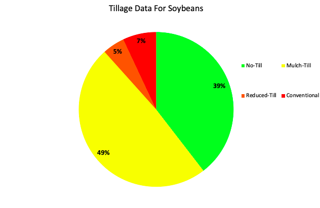
The latest Lake Bloomington Transect Survey was conducted on 105 McLean County field locations. Comparable to prior surveys these results suggest a decrease in no-till and increase in conventional tillage practices. Results on corn acres showed 45% Conventional Till, 30% Mulch Till, 23% Reduced Till, and 2% No-till. Soybean acres resulted in 49% Mulch Till, 39% No-Till, 7% Conventional, and 5% Reduced Till. The cumulative figures were as follows: 105 locations measured, 18 No-Till fields, 39 Mulch Till fields, 16 Reduce Till fields, and 30 Conventional fields. No Cover Crop residue was found.